Wednesday, June 30, 2010

Western States Images

There was a lot going on out on the course on Saturday, and a lot of folks got some neat shots that really help sum up the day.  Below are a few of my favorites.  Also, my race report is in the hands of the good folks at Running Times and should be posted in less than 24 hours.  I'll provide a link when it's up.

(Running up to Emigrant Pass out of Squaw Valley with Geoff, first thing in the morning. There was an incredible layer of fog hanging out in Squaw Valley and then the spectacular view of Lake Tahoe directly behind us. Photo: Luis Escobar)


(Geoff, Kilian and I as we were from miles 23-45--never more than a few feet apart. Photo: Salomon)


(Dusty Corners (38mi) pit-stop: it looks hectic, but my crew was perfect all day. Photo: Doug White)


(And away I go--leaving Dusty Corners. Photo: Doug White)

(Getting weighed at Devil's Thumb, mile 48.)


(Running into Michigan Bluff at mile 56. I'm obviously excited here because the major canyons are over and I still feel really good. Both of my empty bottles are stuck in the back of my shorts--I was definitely carrying water all day! Rickey Gates sneaks in there with a little video coverage, too. Photo: Glenn Tachiyama)


(Joe escorts me out of Michigan Bluff; still running calm and relaxed even though it's starting to get hot. Photo: Brett Rivers)


(Coming into Foresthill at mile 62 with Jenn.  Still feeling really good but pretty curious as to how I'm ever going to manage to break Kilian. Photo: Megan Zaranek)


(A short video clip at ~70mi on Cal St. I'd just gotten a ton of rocks in my right shoe and needed to stop briefly to get 'em out. This was the only time--other than the raft ride--that I got off my feet the whole race. We caught back up to Kilian and Rickey right after this.)


(Riding across the river at mile 78 with Joe, Rickey, and Kilian. I'm kind of losing it here a bit--just tired and hot. Photo: jLu)


(Emerging from a dunk in the river and preparing to run the hill up to Green Gate at mile 80. Photo: Glenn Tachiyama)


(From left to right: Rickey, me, Jenn, Jorge, and Kilian running up the climb from the River Crossing to Green Gate, ~79mi.  I think this picture shows pretty well why Geoff was able to catch and pass both Kilian and I--we'd been working each other pretty hard for the last 35mi and were hardly ever seperated by more than what is shown in this photograph.  At the top of the hill, Kilian would lie down in the shade and I wouldn't see him again until the finish line. Photo: Luis Escobar)


(Just before the mile 93.5 Highway 49 Crossing. I'm sure I'm looking for Geoff in this shot as I'd been within 50 yards of him just a few minutes earlier. Photo: Carl Costas)


(Running across No Hands Bridge at mile 96.8 with Jenn trailing me. Photo: Megan Zaranek)


(Wow. Pretty intense moment here at ~97mi. Jenn and I had just crossed No Hands Bridge where we were erroneously told that Geoff was only 3-4min up (it was actually 5 or 6min). I'm doing everything I possibly can to rally any kind of charge to make one final bid at the win. On the almost three mile descent to No Hands I knew I wasn't going fast enough to catch Geoff, but it's all my quads would allow, so I was just hoping that he would blow up a little on the Robie Point climb and maybe I'd be able to catch sight of him again like I had a half an hour earlier on the climb up to Highway 49.  Geoff closed extremely well and timed his final surge perfectly. Photo: Luis Escobar)


(Finishing 2nd, six minutes behind Geoff and 23min under Scott's old CR. I guess this picture shows why you run the WS100--the competition is top-notch and people get excited about it. In North America, probably only the Leadville 100 approaches the same level of interest at the finish line and along the course throughout the day, and it's not even nearly this high. Photo: Luis Escobar)


(Pretty happy to be done--Geoff is standing there to greet me. Photo: Carl Costas)


(Congratulations from the Sheltonator. Photo: Glenn Tachiyama)


(Five-time winner, 25-time finisher, and WSER Board President Tim Twietmeyer interviewing me moments after finishing.  I'm mostly just psyched to be off my feet! Photo: jLu)


(Media scrum: people get excited about this race! Photo: Luis Escobar)


(Rickey provided the contraband. Photo: jLu)


(Congratulating the man I ran with all day. Photo: jLu)

Tuesday, June 29, 2010

Pre-WS100

Well, what a race.  I'll post an in-depth race report for this past weekend's Western States 100 sometime in the next few days, but for now I'll just say that it was the most fun I've had probably in any race ever.  True head-to-head competition is a blast and I think the sport of mountain ultra running--both the fans and competitors--would benefit from more situations like what materialized Saturday in the Sierras.  It'd be exciting if more events provided the requisite incentives to make it happen.

In the meantime, below are the (belated) final two weeks of my training leading into the big race, an article I wrote for Running Times more generally chronicling my training philosophy for the event,  and then a few photos from the days leading up to the race.

06-14-2010
Mon-AM: 50 miles (7:48) 2xGreen-Walker-Eldo-2xGreen, 13000'
Still a bit rainy, but I did about 5hr of this run with Scott. Easy effort all day.

06-15-2010
Tue-AM: 15 miles (2:22) Green Mt., 3000'
PM: 10 miles (1:21) Streets+Sanitas Valley w/ Joe, 800'

06-16-2010
Wed-AM: 18 miles (2:55) Green Mt. & Bear Peak, 4200'
Nice easy effort with Scott.
PM: 6 miles (:47) Skunk Creek+barefoot

06-17-2010
Thu-AM: 15 miles (2:15) Green Mt., 3000'
PM: 8 miles (1:03) Creek Path+barefoot

06-18-2010
Fri-AM: 16 miles (2:19) Green Mt. w/ Scott, 3000'
PM: 8 miles (1:03) Creek Path+barefoot

06-19-2010
Sat-AM: 15 miles (2:10) Green Mt. w/ Scott, 3000'
PM: 8 miles (1:02) Creek Path+barefoot

06-20-2010
Sun-AM: 15 miles (2:14) Green Mt., 3000'

Total
-Miles: 184
-Hours: 27h 14min
-Vertical: 33,000'
--------------------------------------------------------------------
06-21-2010
Mon-AM: 8 miles (1:00) Creek Path

06-22-2010
Tue-AM: 8 miles (1:00) Kokopelli Trail

06-23-2010
Wed-AM: 8 miles (1:00) Tahoe Rim Trail

06-24-2010
Thu-AM: 7 miles (1:00) Volcano Canyon from Bath Rd, 1500'

06-25-2010
Fri-AM: 4 miles (:36) Truckee River

06-26-2010
Sat-AM: 100 miles (15:13:53) Western States 100, 18000'
2nd Place

06-27-2010
Sun- an appropriate amount of hobbling

Total
-Miles: 135
-Hours: 19h 50min
Vertical: 19,500'

(Designer extraordinaire jLu in her Boulder sweatshop putting some crucial finishing touches on the race shorts.)


(Relaxing through the taper with some slacklining in North Boulder Park.)


(In jLu's office, going over some final logistics with 2/3rds of my crew.)


(Geoff and I at the pre-race check-in in Squaw Valley.)


(Rickey Gates interviewing me after the pre-race meeting.)


(Where's the Mt. Dew? The final 1/3 of my crew, clearly psyched to be awake at 4am.)


(Last minute gel-stashing on race morning. Also, the last time my new pink kicks would look so sharp.)


(I had the most dialed crew on the course: Jenn, Joe, and jLu.)


(Getting some last-second rest, just moments before the start...)

(All photos: jLu)

Sunday, June 13, 2010

Weekly Summary: June 7-13

06-07-2010
Mon-AM: 14 miles (2:17) Green Mt. up Back down Gman, 2800'
Predictably dead today. Went very easy.
PM: 9 miles (1:13) Creek Path+Campus
Hot and relatively humid. Temps in the 90s. Legs felt way better than this morning.

06-08-2010
Tue-AM: 15 miles (2:15) Green Mt. up Back down Bear Cyn, 3000'
Felt like a human being again this morning. Which is nice.
PM: 9 miles (1:12) Skunk Creek+3mi barefoot at Kitt
Ended up doing the barefoot with Carney (but he was in his usual boats). We got carried away talking so we did a mile more than I'd planned. Boulder Creek borderline flooding today.

06-09-2010
Wed-AM: 16 miles (2:28) Green Mt. & Bear Peak, 4200'
Casual 32:42 up the frontside of Green showed me my legs were back, so I tacked on a nice cruise up Bear's West Ridge. Actually had a fun time descending Fern Canyon. This is probably my favorite loop to do in Boulder. Took a comedic tumble when I caught a toe coming down Skunk Canyon. Somersaulted head-first off the steep trail and dropped into a deep thicket of plum-brush that left my whole right side pock-marked with thorns.  Luckily, no one saw me, but now a few days later I think I may have picked up a bit of poison ivy?
PM: 8 miles (1:04) Creek Path+3mi barefoot at Kitt
Nice hot weather--hit this run mid-day to get some heat. Had a helpful acupuncture session with Allison Suddard in the evening.

06-10-2010
Thu-AM: 27 miles (4:24) Pikes Peak Summit, 8000'
Caught a ride to Manitou with Jeff and a couple of his friends. Took a while for my legs to get going (I'm used to a little more warm-up before hitting a big hill like that), but once on Barr I couldn't believe how much more shallow it is compared to what I've gotten used to running in Boulder. 1:22 nice and relaxed to Barr Camp from the start at Memorial Park and another 1:12 to the summit (legs finally warmed up) despite maybe half a dozen stretches of still not insignificant snow in the final two miles (some postholing--but it will probably be all clear within another week) and still lacking any real acclimation. Descended casually as I didn't want to be too tired for the weekend long run and made it down to the finish line in 1:42 from the top for a 4:16 for the full PPM. Back at Memorial I jogged a few more minutes to round out 27 miles. Stopped momentarily at BC on the way down, but unfortunately Neal and Teresa weren't in--haven't seen them in a while. Still my favorite mountain of all time. It's just so damn big and feels like home.
PM: 5 miles (:42) Creek Path
Just running some errands--returned a library book, mailed a bill, picked up a few groceries.


06-11-2010
Fri-AM: 15 miles (2:10) Green Mt. up Greg-Gman down Front, 3000'
Fun easy run with Jeff on some vintage routes. The northeast ridge and 2nd Flatiron trail offer some premo views. Finished up with 2mi of barefoot at Kitt.


06-12-2010
Sat-AM: 16 miles (2:16) Green Mt., up Back down Bear Cyn, 3000'
Raining the whole way. Some sleet/graupel fell higher on the mountain. Weather is causing me to push the final long run back a couple of days. At first it felt good to thaw out in the sauna afterwards--but, then pretty quickly it sucked just as much as usual.
PM: 8 miles (1:01) Creek Path+3mi barefoot at Kitt
Raining.  Still.


06-13-2010
Sun-AM: 17 miles (2:25) Green Mt. up Back down Bear Cyn, 3000'
Still raining. Gave Jurker the tour and did a lot of splashing through the high water in Bear Cyn. Legs feeling great, hope to get out for one last semi-long one tomorrow to give Scott a real picture of the area. Hopefully, by time I'm recovered from WS he'll be fully acclimated and we can do a lot of sweet high-country running.
PM: 8 miles (1:03) Creek Path+3mi barefoot at Kitt
Snuck this one in between rain showers.  My goodness, what weather.

Total
-Miles: 167
-Hours: 24h 30min
-Vertical: 27,000'

2010 Summits (Day 164)
Green: 166
Bear: 10
SoBo: 4
14ers: 2

Another very satisfactory week of running in the legs.  All that's really left to do is not run.

Tuesday, June 8, 2010

Monday, June 7, 2010

Weekly Summary: May 31-June 6

05-31-2010
Mon-AM: 15 miles (2:14) Green Mt. up Back down Flagstaff, 2800'
Took it very easy. Felt a lot better by the end.
PM: 8 miles (1:00) Creek Path+3mi barefoot at Kitt

06-01-2010
Tue-AM: 15 miles (2:11) Green Mt. up Back down Bear Cyn, 3000'
Saw a huge black bear walking up the trail towards me in Bear Cyn (right above the lower-most section of new trail).  I stopped and he kept ambling until he saw me, then he stopped only about 25 yards away.  That sucker did not have a rough winter--he was gigantic.  We both stood there just looking at each other for a long time--at least a full minute--until I took a single step towards him and he got the idea and jumped off the trail into the bushes.  Pretty sweet seeing charismatic megafauna like that.
PM: 8 miles (1:01) Enchanted & Kohler Mesas, 700'
Amazing wildflowers up on Kohler Mesa right now.


06-02-2010
Wed-AM: 27 miles (4:05) Boulder Skyline Traverse, 6600'
PM: 8 miles (1:02) Boomerang Hill-Enchanted Mesa, 700'
Legs felt really good for some reason.

06-03-2010
Thu-AM: 15 miles (2:15) Green Mt., up Back down Bear Cyn, 3000'
Ran very easy, so was feeling really good by the end.
PM: 8 miles (1:04) Downtown+3mi barefoot at Kitt
Ran to the bank and post office.

06-04-2010
Fri-AM: 16 miles (2:24) Green Mt. up Back down Flagstaff, 3000'
Ran easy but I had a bunch of energy. Descended Greenman, bopped over Flagstaff, and then down to Eben G. Fine and home on the Creek Path plus a trip to the grocery store.

06-05-2010
Sat-AM: 58 miles (8:22) Almagre Mt. & Mt. Rosa, etc., 11,000'
Incredible day of running.  Felt very strong all day.  Had about another 45min of leisure (picture taking, bottle filling, mountain gazing, etc.) along the way, so it was over a 9hr outing.

06-06-2010
Sun-AM: 15 miles (2:18) Green Mt. up G-man down Long Cyn, 3000'
Legs felt surprisingly good but left achilles was a bit tight.
PM: 15 miles (2:08) Green Mt. up Front down Bear Cyn, 3000'
Ran up the front in 33:23. 90F temps provided good heat training before clouds rolled in on the descent. Saw what I think was a King snake (not the venomous coral snake...I think) on the Mesa Trail.


Total
-Miles: 208
-Hours: 30h 04min
-Vertical: 36,800'

2010 Summits (Day 157)
Green: 160
Bear: 9
SoBo: 4

Saturday, June 5, 2010

Home Trails

(Pikes Peak, with the Incline and Manitou Springs at its base.  What a huge mountain.)

Yesterday I headed down to Colorado Springs in the evening for a change of scenery for today's long run.  Today was to be my longest run in my final preparations for Western States, so I wanted a bunch of trails to choose from instead of just doing multiple loops of Green Mt. and/or Walker Ranch.  Additionally, because I've been doing essentially the same long run for the past two months now--laps of Green with Walker thrown in the middle--I wanted some new terrain where I wouldn't constantly know how many minutes/seconds I was fast or slow from the week before.

(The day's route, without the Garden of the Gods portion.  Pikes Peak in the upper right.)

Before the Leadville 100 last summer I did two 50 milers in the final weeks before the race--one in each direction on the out-and-back course--and because I'm so familiar with splits and checkpoints all along that route I think I ended up doing both of those runs a bit too hard.  The purpose of today's run was to log lots of running time on my feet, but to not feel compelled to hit any specific split or pace.

(Almagre and Rosa top out at 12,350' and 11,500', respectively; I'm not sure why MapMyRun's scale doesn't depict their elevations more accurately. Basically, one 6500' climb and three 1500' climbs for a total of 11k'.)

There are just so many trails to choose from in the Springs.  Today I ran from my friend Brooks' doorstep and, except for a couple short out-and-backs to the tops of climbs, I basically never ran the same trail during nearly 60 miles of running and only had 4mi of pavement (I did start less than a mile from downtown, afterall).  And, I didn't even touch Pikes Peak or the Rampart Range.  And, for very large chunks of that, didn't see a single other person.  Over the past few months I have become quite enamored with Boulder, but in terms of sheer variety of trails and immediacy of access to high altitude, Manitou/Colorado Springs is awfully tough to beat (having lived there for seven years, I admit I have a bit of a bias).

I'll let a few pictures from the day tell the rest of the story: (Warning, 8+ hrs is a long time and there was a whole lot to see, so there are a lot of pictures to follow...)

(The optical illusional twin summits of 11,500' Mt. Rosa as seen from town.  The high point on the left is actually a full 500' higher than the "peak" on the right.)

(A couple miles into the initial 14mi/6500' climb, in Bear Canyon on the 666 trail--affectionately known as either El Diablo or Balls-to-the-Wall (due to its steep nature) by the CC XC teams.  I've drank from the just-uphill source of this spring literally hundreds of times.)

(Brilliantly budding aspen of Jones Park at 9000'.)

(Looking back down the 3000' vert of Bear Creek Canyon, which I just ran up.)

(The buttery smooth single track of the Pipeline Trail has that name for a reason.  Contouring flat for a mile or so at ~9100', this is part of the Ring The Peak route.)

(The beautiful secret single track along North Cheyenne Creek, accessed off of Pipeline.)

(The six mile road climb to the south summit of Almagre.)

(~1mi and 400' to go to the summit towers of 12,350' Almagre.)


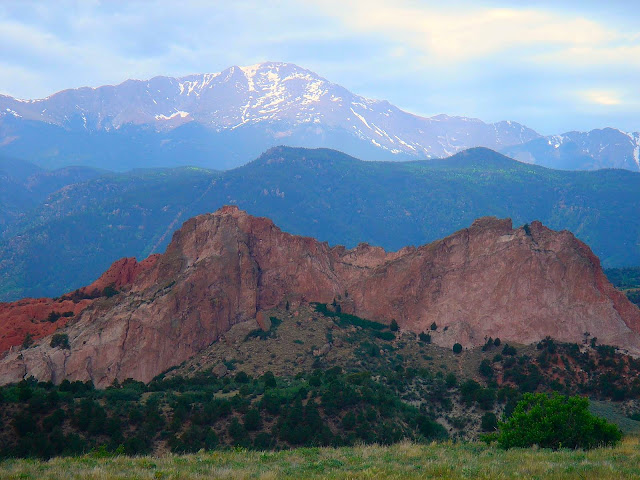
(Pikes Peak from Almagre's summit. You can clearly see the Cog Railway's (very steep) route.)

(What nearly 6500' of vertical relief looks like.  Colorado Springs below.)

(The Sangre De Cristo Mountain Range off to the southwest.)

(Just below the top of Almagre, with Pikes over my shoulder.)

(Running an exquisite ribbon of high ridge single track leading to Rosa's 11,500' summit. One of my favorite sections of trail in the Pikes Peak region.)

(The 4000' drop off of Rosa can have a good bit of gnarl...)

(...or be blissfully perfect.  I've never seen another person on this three mile stretch of trail above St. Mary's Falls.  People are crazy.)

(Part of the 2mi/1500' grunt back up to 9000' on the Seven Bridges Trail.  This climb came after 5hrs of running.)

(The view west up the Cheyenne Creek drainage from 8300' Mt. Buckhorn.  Rosa is in the center of the photo with the road switchbacks on the shoulder of Almagre visible in the upper right corner.)

(After the descent off of Buckhorn and yet another 1500' climb you come to the namesake of the Dog Rock Trail.)

(From the top of Section 16 you can look back across the Bear Creek drainage to see Mt. Buckhorn (on the right) and Mays Peak (on the left).  The steep road cut is High Drive, which I just descended before climbing back up to Dog Rock and Section 16.)

(Some of the flawless, endless single track in Red Rock Canyon.)

(The classic sandstone of the Garden of the Gods.)

(The trail in the Garden that shares the name of my hometown.  Through the curious mechanism of a vast, ancient interior sea, the same white, chalky rock that this trail runs over forms endless bluffs along the Missouri River valley in and near Niobrara, NE and is considered this particular geologic formation's type location.  I also really like this trail in the Garden.)

 
(A parting shot of the mountain that oversees everything.  But, if these pictures show anything, it's that there is a TON of trail running in the Springs that doesn't involve Barr Trail and its crowds.)